Human Orbital Spaceflights
![]()
International Flight No. 166STS-59Endeavour (6)62nd Space Shuttle missionUSA |
 |
 |
![]()
Launch, orbit and landing data
walkout photo |
 |
||||||||||||||||||||||||||||
alternative crew photo |
Crew
| No. | Surname | Given names | Position | Flight No. | Duration | Orbits | |
| 1 | Gutierrez | Sidney McNeill "Sid" | CDR | 2 | 11d 05h 49m 29s | 183 | |
| 2 | Chilton | Kevin Patrick "Chilly" | PLT | 2 | 11d 05h 49m 29s | 183 | |
| 3 | Apt | Jerome "Jay" | MS-1 | 3 | 11d 05h 49m 29s | 183 | |
| 4 | Clifford | Michael Richard Uram "Rich" | MS-2, FE | 2 | 11d 05h 49m 29s | 183 | |
| 5 | Godwin | Linda Maxine | MS-3, PLC, EV-1 | 2 | 11d 05h 49m 29s | 183 | |
| 6 | Jones | Thomas David | MS-4, EV-2 | 1 | 11d 05h 49m 29s | 183 |
Crew seating arrangement
|
 |
|
||||||||||||||||||||||||||||
Hardware
| Orbiter : | OV-105 (6.) |
| SSME (1 / 2 / 3): | 2028 (8.) / 2033 (5.) / 2018 (12.) |
| SRB: | BI-065 / RSRM 37 |
| ET: | ET-63 (LWT-56) |
| OMS Pod: | Left Pod 04 (13.) / Right Pod 01 (19.) |
| FWD RCS Pod: | FRC 5 (6.) |
| RMS: | 303 (7.) |
| EMU: | EMU No. 2030 (PLSS No. 1014) / EMU No. 2014 (PLSS No. 1008) |
Flight
|
Launch from Cape Canaveral (KSC) and
landing on the Edwards
AFB, Runway
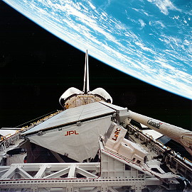
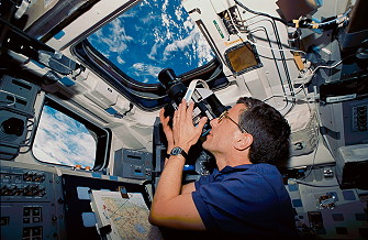
22. A launch attempt on April 07, 1994 was delayed at least one day so that inspections could be done to insure Endeavour does has vanes of the proper radius in its liquid oxygen engine preburner. Inspectors at Rocketdyne's engine plant in Canoga Park, California discovered flaws in two components being tested and concerns were raised that Endeavour's engines could contain similar components. The preburner's 3-inch nickel alloy vanes should have rounded tips while the vanes discovered by Rocketdyne had sharper tips. Engineers were concerned the sharper tips have a higher probability of cracking and that could cause a piece of debris to be pulled into the Liquid Oxygen High Pressure Oxydizer Turbopump (HPOT). This, in turn, could cause a premature engine shutdown. The inspections involved snaking a borescope thru the engine components on Endeavour and inspecting the engine vanes. Endeavour was verified to be in the proper configuration. The launch attempt on April 08, 1994 was scheduled for 12:07 UTC but the launch team protected an option in the countdown timeline which would allow Endeavour to launch one hour sooner at 11:07 UTC. By building flexibility into the launch time, NASA managers can evaluate predicted climatological and atmospheric conditions for the KSC area during the final part of the countdown and then select the optimum time for launch. The launch attempt on April 08, 1994 was delayed due to low cloud cover and then finally scrubbed at T-5 min due to bad weather (cross winds out of limits) at the Shuttle Landing Facility. A 24-hour turnaround scrub was initiated. STS-59 carried out the Space Radar Laboratory (SRL) payload in Endeavour's cargo bay to give scientists highly detailed information that will help them distinguish human-induced environmental changes from other natural forms of change. The crew took radar images of the Earth and Earth observations photography (more than 14,000 still photographs). In addition, experiments in the areas of biology and physics were carried out. The crew was divided in two 12-hour-shifts. The Red Shift consisted of Sidney Gutierrez, Kevin Chilton and Linda Godwin. Members of the Blue Shift were Jerome Apt, Michael Clifford and Thomas Jones. The Space Radar Laboratory-1 (SRL-1) comprised two elements: a suite of radar instruments called Spaceborne Imaging Radar-C/X-Band Synthetic Aperture Radar (SIR-C/X-SAR) jointly developed by NASA with DARA of Germany and ASI of Italy, and an atmospheric instrument called Measurement of Air Pollution from Satellite (MAPS). SRL was part of NASA's Mission to Planet Earth, the agency's program that is studying how our global environment is changing. The SIR-C/X-SAR radar data provided information about how elements of the complex "Earth system" Q particularly land surfaces, water and life Q work together to create Earth's livable environment. The science team was particularly interested in studying vegetation coverage, the extent of snow packs, wetland areas, geologic features such as rock types and their distribution, volcanic processes, ocean wave heights and wind speeds. SIR-C was a two-frequency radar including L-band (23-cm wavelength) and C-band (6-cm wavelength). SIR-C represented a technological advance from previous imaging radar. Just as color pictures contain more information than do black and white pictures, SIR-C's multi-frequency, multi-polarization radar imagery provide more information about Earth's surface features than do single- frequency, single-polarization images. SIR-C was the first spaceborne radar with the ability to transmit and receive horizontally (H) and vertically (V) polarized waves at both frequencies. Polarization describes how the radar wave travels in space. The interaction between the transmitted waves and the Earth's surface determines the polarization of the waves received by the antenna. For example, when data are acquired with HH (horizontal- horizontal) polarization, the wave is transmitted from the antenna in the horizontal plane and the antenna receives the backscattered radiation in the horizontal plane. The other polarizations are HV (horizontally transmitted, vertically received), VH (vertical-horizontal) and VV (vertical-vertical). The SIR-C antenna was the most massive piece of flight hardware ever built at JPL. Its mass was 23,100 pounds (10,500 kilograms) and it measured approximately 39 feet by 13 feet (12 meters by 4 meters). The instrument was composed of several subsystems: the antenna array, transmitter, receivers, data-handling subsystem and the ground processor. The antenna consisted of three leaves, each divided into four subpanels. X-SAR was built by the Dornier and Alenia Spazio companies for the German Space Agency, Deutsche Agentur fur Raumfahrtangelegenheiten (DARA), and the Italian space agency, Agenzia Spaziale Italiana (ASI), respectively. The scientific processing progress is managed by DARA. It was a single-polarization radar operating at X- band (3-cm wavelength). X-SAR used a slotted-waveguide antenna, which was finely tuned to produce a narrow, pencil-thin beam of energy. The X-SAR antenna was mounted on a supporting structure that is tilted mechanically to align the X-band beam with the L-band and C-band beams. X-SAR will provide VV polarization images. The SIR-C and X-SAR instruments could be operated individually or in conjunction. The width of the ground swath varied from 9 to 56 miles (15 to 90 kilometers), depending on the orientation of the antenna beams. The resolution of the radars Q the size of the smallest objects they can distinguish Q could be varied from 33 to 656 feet (10 to 200 meters). The Measurement of Air Pollution from Satellite (MAPS) experiment measured the global distribution of carbon monoxide in the troposphere, or lower atmosphere. Measurements of carbon monoxide, an important element in several chemical cycles, provide scientists with indications of how well the atmosphere can clean itself of "greenhouse gases", chemicals that can increase the atmosphere's temperature. MAPS' primary goal was to measure the distribution of carbon monoxide in the atmosphere between the altitudes of 2 and 10 miles (4 and 15 kilometers). The data were recorded on a tape recorder and transmitted directly to the ground using the Space Shuttle telemetry system. The signals will be processed at the Payload Operations Control Center to produce "quick look" maps of the carbon monoxide distribution. These "quick look" data were used to plan the exact periods of data acquisition during the flight. Following the flight, the recorded data were processed using more refined techniques, and the data were combined with ground-and aircraft-based data obtained by collaborating scientists from several countries. This presented a more detailed description of the distribution of the gas than can be obtained by any single technique. The MAPS hardware consisted of an optical box, an electronics box, a tape recorder and a camera, all mounted to a single base plate. This assembly was mounted to a Multi- purpose Experiment Support Structure near the forward end of the cargo bay. The instrument was about 36 inches (91 centimeters) long, 30 inches (76 centimeters) wide and 23 inches (58 centimeters) high. It weighed 203 pounds (92 kg) and consumed about 125 watts of electrical power. During the initial activation of the X-Band Synthetic Aperture Radar (X-SAR), controllers reported they were unable to fully power up the amplifier that provides power to the radar. The problem was in the low voltage circuit internal to the power amplifier. Engineers were not immediately able to explain the problem, so they turned off the power amplifier for about three hours. The problem was traced to an oversensitive protection circuit, a type of circuit breaker. The radar lab engineers bypassed the protection circuit and turned on the instrument. It worked then without any incident. The radar laboratory had taken data readings on more than 40 targets including Howland, Maine; Macquarie Island; the Black Sea; Matera, Italy; and the Strait of Gibraltar. Scientists also gathered information on three of 19 "supersites," the highest priority targets for that day. Sunday's supersite observations were global carbon and hydrologic cycles in Duke Forest, North Carolina; hydrologic cycles around Ötzal, Austria; and geological data on Lake Chad in the Sahara. The data recorded during the STS-59 mission would fill the equivalent of 20,000 encyclopedia volumes. Payload managers reported that more than 70 million square kilometers of the Earth's surface, including land and sea, have been mapped on this flight. This figure represents about 12 percent of Earth's total surface. The Space Radar Laboratory obtained radar images of approximately 25 percent of the planet's land surfaces. The Visual Function Tester-4 (VFT-4) was designed to measure near and far points of clear vision as well as the ability to change focus within the range of clear vision. VFT-4 provided data to evaluate on orbit refractive and accommodative changes in vision over a period of several days. The VFT-4 payload consisted of the experiment unit, a cable connecting VFT-4 to a computer serial port, 2 self-booting floppy disks containing a software program and serving as a data storage medium, a payload and general support computer with power and data cables and a standard 28-volt power cable. STS-59 flew the first cooperative initiative with the National Institutes of Health (NIH). The joint initiative in cell biology used a special cell culture system developed by the Walter Reed Army Institute of Research, Washington, D.C. The system, known as Space Tissue Loss-4 (STL-4), was fully automated and provided fluid replenishment, oxygen/carbon dioxide and temperature controls to provide for cell growth in microgravity. The cells will be analyzed post-flight. The experiments on this first NIH/NASA cooperative flight examined the effects of microgravity on muscle and bone cells. Preliminary flight tests using this cell culture system have indicated there may be effects in the rate in which new muscle and bone cells are formed in microgravity. This research will help understand what is happening on the cellular level to astronauts who suffer from bone loss and muscle deterioration in spaceflight. This research also should contribute to understanding of the mechanisms involved in bone loss and muscle atrophy on Earth. An advanced cell culture device known as STL-5 was flown on STS-59. This was the first flight test of this hardware developed by the Walter Reed Army Institute of Research, Washington, D.C. This new system included a video-microscope that allowed scientists on the ground to see real-time video images of their experiments in space. The instrument was designed to be controlled by either astronauts in space or individuals on the ground. This telescience from the middeck opens up the possibility for scientists to monitor and control their space experiments from the ground. The objective of this flight was to test the operation of the equipment in microgravity. Fish eggs were used to test the imaging capability of the system. As part of the Shuttle Amateur Radio Experiment (SAREX) students in the United States, Finland and Australia had a chance to speak via amateur radio with astronauts aboard the Space Shuttle Endeavour during STS-59. Ground-based amateur radio operators ("hams") were able to contact the Shuttle through automated computer-to-computer amateur (packet) radio links. There also were voice contacts with the general ham community as time permitted. Shuttle mission specialists Linda Godwin (call sign N5RAX) and Jerome Apt (N5QWL) talked with students in 9 schools in the United States, Finland and Australia using "ham radio". NASA tested an improved thermal protection tile on the STS-59 mission. Known as Toughened Uni-Piece Fibrous Insulation (TUFI), the new tile material was an advanced version of the material that protects the Space Shuttles from the intense heat that builds up as they re-enter Earth's atmosphere. During preparations for this mission, Rockwell technicians at Kennedy Space Center placed several TUFI tiles on Endeavour's base heat shield, between the three main engines. At the end of the mission, NASA and Rockwell technicians examined the tiles and compared the damage with that seen on previous missions using the originally designed tile material. The current tiles were a rigid glass fiber composite with a thin, fully dense glass coating that sits on top. When it got hit with a rock or other debris, the coating cracked or chipped. This required either patching or replacement, depending on the extent of damage. Because TUFI permeated the pores nearer the surface of the insulation material, providing reinforcement to the composite surface, it is less subject to impact damage. The porous surface also stopped cracks from spreading, which limits damage to the tile. Because there is less damage, repair is easier and faster, and fewer tiles should need replacement. This should result in lower repair costs. The landing was originally scheduled 15:52 UTC on Tuesday, April 19, 1994 on KSC's runway 33. The landing was postponed a day due to weather violations in the landing area. The first opportunity was waived off due to cloud cover obscured clear visibility of the runway. The second (and last) KSC landing opportunity for April 19, 1994 (which would have resulted in a landing at 16:23 UTC) was also waived due to clouds and high winds in the vicinity of the Shuttle Landing Facility. The decision was made following near continuous review of the weather conditions by flight controllers at the Johnson Space Center and Astronaut Robert Gibson flying the Shuttle Training Aircraft at the landing site. Endeavour and its six astronauts remain in space an additional day and finally diverted to the Edwards AFB. |
Photos / Graphics
 |
 |
 |
 |
 |
 |
 |
 |
 |
 |
 |
|
more Earth observation photos |
|
| © |  |
Last update on June 19, 2023.  |
 |